By The SUN
 |
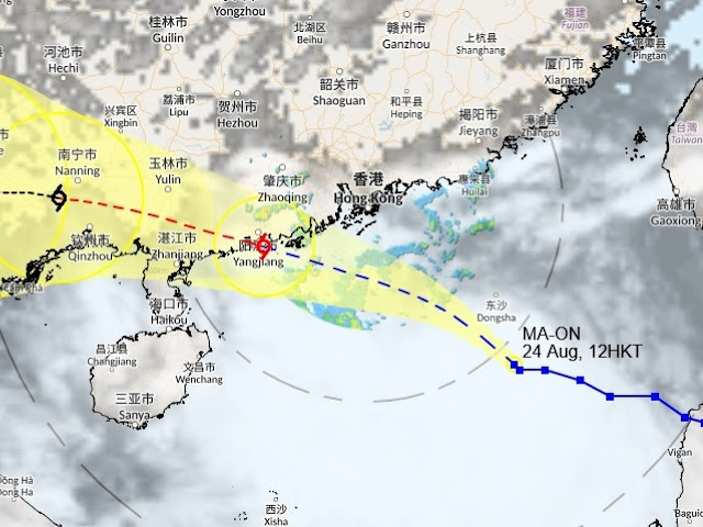
| The Observatory's graphic tracks Ma-On's movement as it heads towards Guangdong |
The Observatory issued Standby Strong Wind Signal No.3 at 12:40pm today,
Wednesday, and said the signal may be raised to T8 between 6pm and 9pm tonight as
Severe Tropical Storm Ma-on moves closer to Hong Kong.
At noon, Ma-on was centred about 440km southeast of Hong Kong, and is forecast to move toward the coast of western Guangdong.
 |
| PINDUTIN PARA SA DETALYE |
The Observatory said the weather will gradually worsen later today. However, the typhoon will come closest to Hong Kong only tomorrow morning, when it may skirt within about 200km south-southwest of the territory, posing considerable threat.
 |
| PINDUTIN PARA SA DETALYE |
Ma-on is forecast to have maximum sustained winds of 120 kilometers an hour when it makes landfall early tomorrow.
The Observatory warned of possible rough to high seas and swells, and urged the public to take precautions against strong winds and flooding.
 |
| PRESS FOR DETAILS! |
Fishing boats and other small sea vessels have been advised not to venture out into the sea, while larger sea vessels have been alerted against big waves.
The severe tropical storm, called Florita in the Philippines, left the country’s “area of responsibility” at past 9am today, but continued to bring associated heavy rains and strong winds in the Ilocos Region, Abra and Benguet.
 |
| Press for details |
Damage to property has been
moderate, despite the government’s order to shut down all offices and schools in
the National Capital Region and nearby provinces yesterday and today.
Latest reports from the country said about 1,344 families, or some 4,600 individuals have been displaced by the typhoon from 60 barangays in the Ilocos, Cagayan Valley and Cordillera regions.
 |
| Tunghayan ang isa na namang kwentong Dream Love |
But the national disaster
relief agency has yet to give an estimate of the damage wrought by the typhoon
to crops and infrastructure.
 |
| PADALA NA! |
 |
| CALL US! |
.jpg) |
| PRESS FOR DETAILS |


